You can modify the settings from the Side Bar Navigation. This will allow you to configure your preferences when using EarthRanger.
General
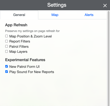
In General, you will find the ability to keep some settings after refreshing the page and try new experimental features.
App Refresh
By selecting any of the following options, the settings will display the information and will stay the same when refreshing the page.
- Map Position & Zoom Level - When refreshing the page, the position and the zoom level you were last located in the map will remain the same.
- Report Filters - By selecting this setting, any change on the view of the reports filters will stay the same when refreshing.
- Patrol Filters - By selecting this setting, any change on the view of the patrol filters will stay the same when refreshing.
- Map layers - Any active or deactivated layer from Map Layers will remain active or inactive when refreshing the page.
Experimental Features
In here you will find the experimental features that you can activate and start experiencing.
You will likely see new features available for trial that will be changing overtime.
Map
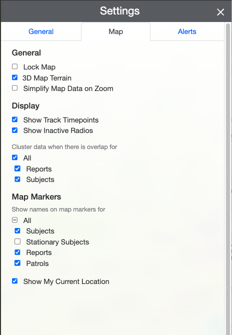
With Map Settings you will be able to configure how the information is displayed in the Map.
General
- Lock Map - Locks the map in the exact position you have selected. Meaning that you will not be able to move the map or pointer.
- 3D Map Terrain - Allows a 3D view of the terrain surface on map.
- Simplify Map Data on Zoom - When zooming in the data on the map will simplify.
Display
- Show Track Timepoints - Shows or hides the track timepoints on the map.
- Show Inactive Radios - Shows or hides the radios that are inactive.
- Cluster data when there is overlap for - When the data starts to overlap, this options allow you to create clusters or groups of the data in similar locations.
- All - Allows all the data to create clusters.
- Reports - Allows only Reports to create clusters.
- Subjects - Allows only Subjects to create clusters.
Map Markers
- Show names on map markers for - When a map marker appears on the map, you will be able to allow it to show the name of each marker or only appear as an icon.
- All - All of the options will appear with the name on the map.
- Subjects - Only subjects will have a visible name on the map.
- Stationary Subjects - Only stationary subjects will have a visible name on the map.
- Reports - Only reports will have a visible name on the map.
- Patrols - Only patrols will have a visible name on the map.
- Show My Current Location - Allow EarthRanger to show your current location.
Alerts
How To Configure My Alerts
In EarthRanger you can configure your own Alerts based on your personal needs and can review the process in